Cyclone Ditwah Weakens Near Chennai, Bringing Steady Rains
As Cyclone Ditwah Fades, Chennai Braces for Continued Rainfall
After battering Sri Lanka and causing widespread devastation, Cyclone Ditwah has weakened as it approaches the coast of Tamil Nadu. According to the latest bulletin from the India Meteorological Department (IMD), the system has degraded into a deep depression while hovering over the southwest Bay of Bengal, moving nearly parallel to the North Tamil Nadu–Puducherry coastline.
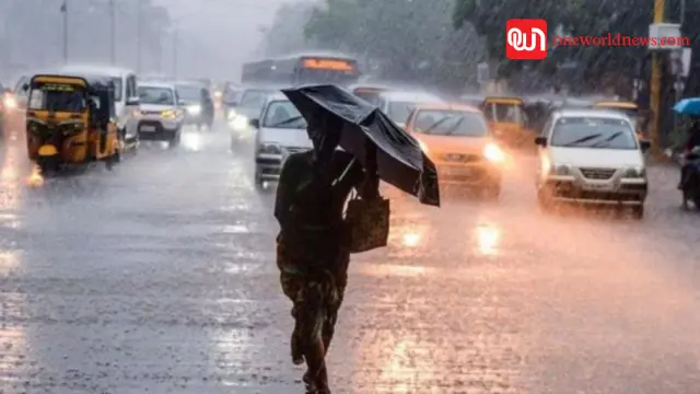
Despite the drop in intensity, Ditwah continues to bring moderate to heavy rainfall over coastal districts — including the region around Chennai — along with gusty winds and unsettled weather.
Rainfall Spreads to Chennai and Coastal Districts
As the cyclone skirts close to shore, many delta and coastal districts have already reported significant rainfall. Areas like Karaikal, Nagapattinam and Cuddalore logged high rainfall totals — Karaikal alone saw as much as 191 mm.
In Chennai too, residents witnessed steady showers. Data from weather stations shows rainfall of around 3 cm in the 24 hours ending Sunday morning, with some spots receiving up to 5.58 cm.
While the downpour has eased fears of intense flooding, local authorities continue monitoring waterlogging in low-lying areas — especially the suburbs and coastal stretches.
Disruption and Precautionary Measures
In anticipation of strong winds and heavy rain, flights from Chennai International Airport were cancelled, and rail services in some coastal areas were disrupted.
Schools and colleges remain shut in several districts as a safety precaution, while disaster-response teams, including elements of National Disaster Response Force (NDRF), have been deployed or put on standby in vulnerable areas.
Authorities have also issued warnings advising people — especially fishermen — to stay away from the sea and coastal zones until conditions stabilize.
What Lies Ahead: More Rain, Slow Dissipation
Even though the cyclone has weakened, meteorologists warn that the remnant system will likely linger near the coast for another 24 hours. As it drifts northwards, cloud bands may re-develop — raising the possibility of renewed rainfall, thunderstorms or gusty winds over parts of North Tamil Nadu, including the Chennai–Tiruvallur–Kancheepuram–Chengalpattu (KTCC) belt.
Meanwhile, the IMD has forecast localized heavy to very heavy rainfall in coastal and delta districts, with patches of “extremely heavy rainfall” possible — prompting authorities to keep public alerts active.
Context: Sri Lanka Hit Hard, Tamil Nadu Faces Spillover Effects
While Ditwah has weakened near India’s coast, its impact was far more devastating for neighbouring Sri Lanka, where flooding and landslides caused by the storm resulted in many casualties and widespread damage.
For Tamil Nadu — including Chennai — the cyclone’s residual rain and wind have caused disruption, but the city so far has avoided a full-blown flood crisis. Still, as long as Ditwah’s remnants swirl offshore, residents and local authorities remain vigilant.
What Residents Should Do: Stay Alert, Stay Safe
Even with the storm weakening, precautions remain important:
- Avoid coastal areas, low-lying zones and the sea.
- Refrain from unnecessary travel, especially near water-logged roads or during heavy showers.
- Follow updates from the IMD and local authorities.
- Keep emergency contact numbers and essential supplies ready, just in case heavy rain returns.